Kempsey Riverside Precinct Foreshore Stabilisation
- Project typeGrant-funded
- Project value$7.36m.
- Project scheduleOctober 2024 - June 2026
- Contractor namePCA Ground Engineering
- Completion Date30 June 2026
Project summary
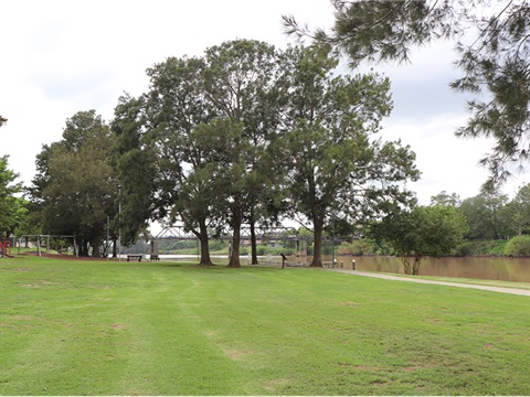
Riverside park in Central Kempsey is a popular and valuable public resource that hosts a variety of popular community events. The area offers numerous amenities, including playgrounds, barbecue and picnic facilities, jetties, a boat ramp, pathways, and event spaces.
The area is a cherished social gathering space for the local community, and has been subjected to recurrent flooding, jeopardising the safety, accessibility, and enjoyment of the area. The March 2021 floods inflicted extensive damage, necessitating prolonged closures and causing further erosion, loss of land, and open space.
The Riverside Precinct Foreshore Stabilisation project aims to protect critical assets like the Kempsey Traffic Bridge and the CBD flood levee, ensuring that these vital components remain intact, allowing access to key areas of the town. A comprehensive analysis was conducted, considering various factors such as local river ecology and community needs.
The bank of the Macleay River in the riverside precinct is subject to significant erosion during flood events, creating loss of recreational land and the risk of impacting assets. Extensive studies and investigations have been done to create a long term solution for this problem.
The Riverside Precinct Foreshore Stabilisation project consists of installing a sheet pile wall to protect the bank against further erosion, protect assets in the Riverside Precinct, improve ease of flood recovery, and provide a more functional space for the community.
The sheet pile wall is an arrangement of interlocking steel sheets and anchor system running parallel to the riverbank, with a concrete capping beam. It will be buried within the bank rather than pace on the face of the riverbank.
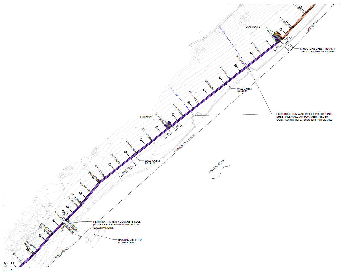
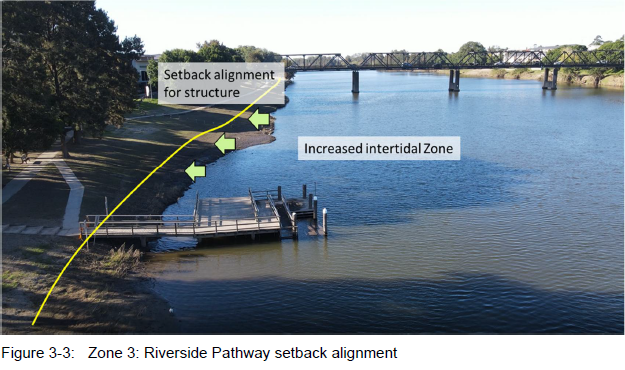
The location of the wall being set back from the hinge point of the bank means there is minimal environmental impact on the waterway during construction. Natural erosion and climate change impact will occur over time and may expose the sheet pile wall. A series of stairways will be constructed along the wall to provide access to and egress from the water for safety and recreational use.
The sheet pile wall was chosen for its adaptability and small footprint, which allows for the integration of future infrastructure.
The project also includes the replacement of the wharf and an extension of the existing footpath, creating a riverside promenade for all to enjoy. This first step will stabilise the foreshore and preserve valuable recreational land.
As the area transforms, the community will benefit from a more resilient and accessible riverside, offering enhanced spaces for leisure and social activities. The improvements will boost local pride and ensure that Riverside Park remains a vibrant gathering spot for future generations to enjoy.

The project also includes the replacement of the wharf, additions to the existing footpath, and new seating areas. This first step is to stabilise the foreshore and preserve valuable recreational land. Below is an example of the proposed seating to be added along the footpath.

Project value and funding source
KSC have been successful in obtaining grant funding to deliver this project under the joint Australian and NSW Government funded Community Asset Program (CAP) and Community Local Infrastructure Recovery Program (CLIRP), for a combined total of $7.36m.
Project impact
Pedestrian movements along the riverbank will be limited from the stairs at the RSL Club to the John St Boat ramp. The footpath from the RSL stairs to approximately 20m north of the playground will be closed for the duration of the project until the footpath is replaced. The footpath along the road at Verge St from the RSL to the Riverside Park car park will not be affected and will be the detour route for pedestrians wanting to access Riverside Park from the Forth Street end.
The park/playground facilities and car park will not be affected.
Both wharves and the northern boat ramp will be closed from the 28 January (after long weekend) 2025 to allow machinery access to the riverbank. The Riverside Wharf will be replaced as part of the foreshore works and is expected to be completed towards the end of June 2026.
Temporary works will be completed on the southern boat ramp to enhance usability prior to closing the northern boat ramp.
Traffic control and signage arrangements will be in place to direct users and any boat ramp users that are concerned with access should talk directly to the Contractor's supervisor onsite.
We appreciate the public's cooperation with signage, traffic control and pedestrian management throughout the construction of this important project for our community.
The finger wharf was destroyed in the May 2025 flood and Council is seeking funding to replace it. The wharf will not be replaced as part of this project.
Understandably, there have been delays in progress due to the repeated wet weather and flood events from March to August 2025.
Despite these delays, the Contractor aims to complete the sheet pile wall portion of the works by the end of 2025. This will allow Council crews to begin other works, including footpath replacement and extensions, seat installation and wharf construction with aim of completing all works by June 2026, weather permitting.
Timeline
January 2023
Council is developing a new design for the riverbank foreshore.
February 2024
The field investigation works concluded
June 2024
Project design completed
July 2024
The construction package out for tender
October 2024
Contract approved by Council.
November 2024
Contract awarded to PCA Ground Engineering
December 2024
Pre-construction works, including baseline noise monitoring, survey set out, service locating, and management plan development.
January 2025
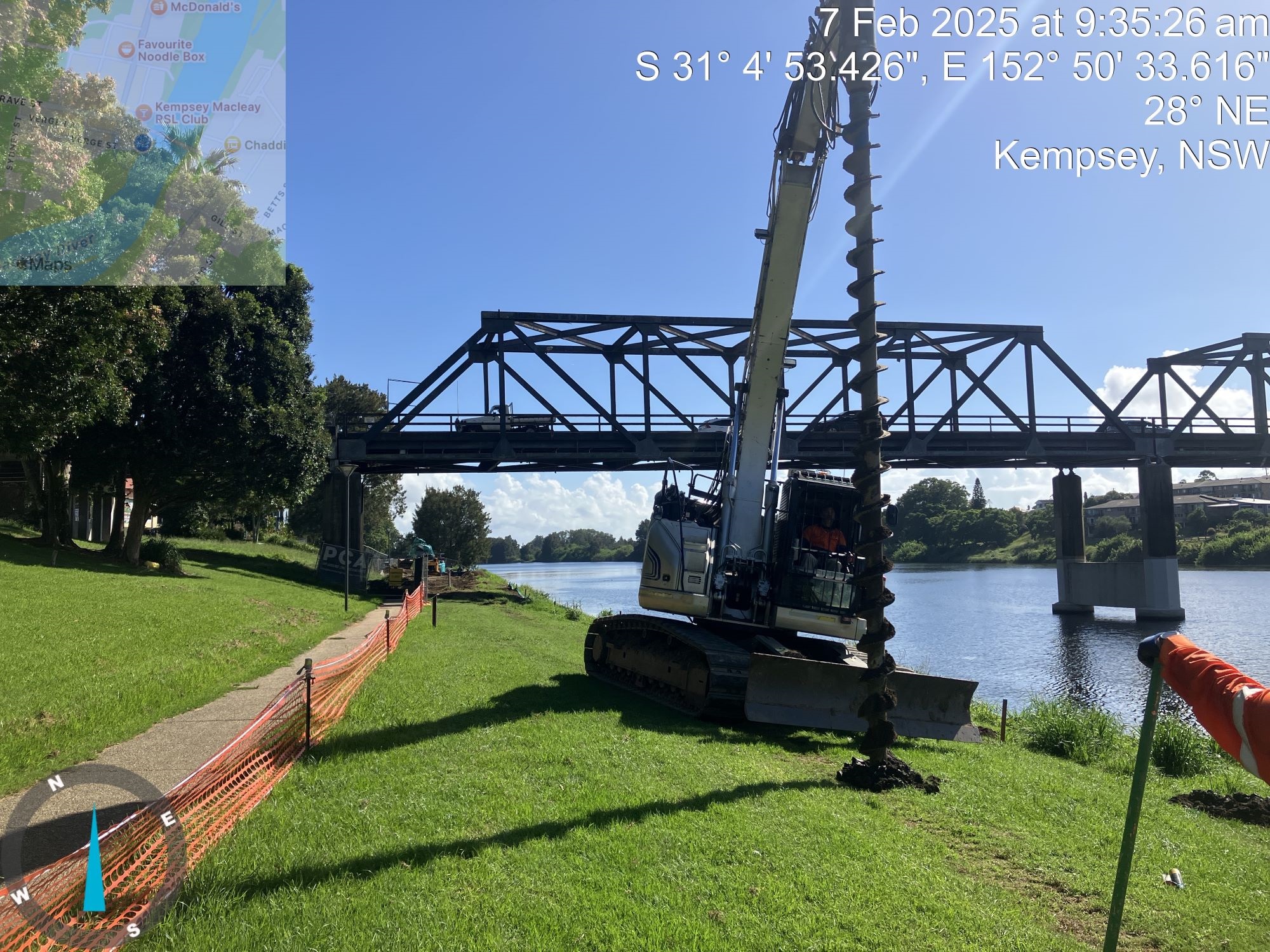
Site establishment and commencement of construction works from 13th January. This includes creating site compound, material deliveries to John Street boat ramp (via Sydney and Austral Streets), erecting site fencing along the riverbank, and implementing pedestrian and traffic controls to keep park users safe. Piling works to commence from the 20 January.
February 2025
Piling works continue. Northern boat ramp closed for public safety and contractor site activity.
Works are progressing well and on schedule despite inclement weather and river activity. Contractor has been monitoring condition of the riverbank and walkways and have implemented pedestrian management controls (including closure of the boat ramp, wharves, and sections of footpath and riverbank) where necessary in the interest of maintaining public safety and separation from the construction zone, whilst providing the public as much access as possible. Ongoing provision and management of environmental controls is occurring with noise and vibration monitoring in place, erosion and sediment control, and ongoing consultation with key stakeholders.
April 2025
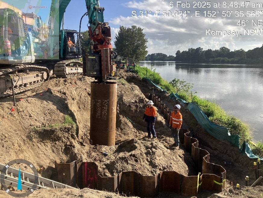
- 230 sheet pile units installed (138m/467m)
- Concrete capping beam in Work Area 4 finished (22.2m/477m)
- 6 circular hollow section piles installed (6/42 units)
While construction activities progress for the sheet pile wall, Council staff are preparing design and construction plans for the footpath and wharf replacement works which will begin upon completion of the sheet piling works, due mid-October.
May 2025
Major flooding delays project.
July 2025
Footpath design completed.
August 2025
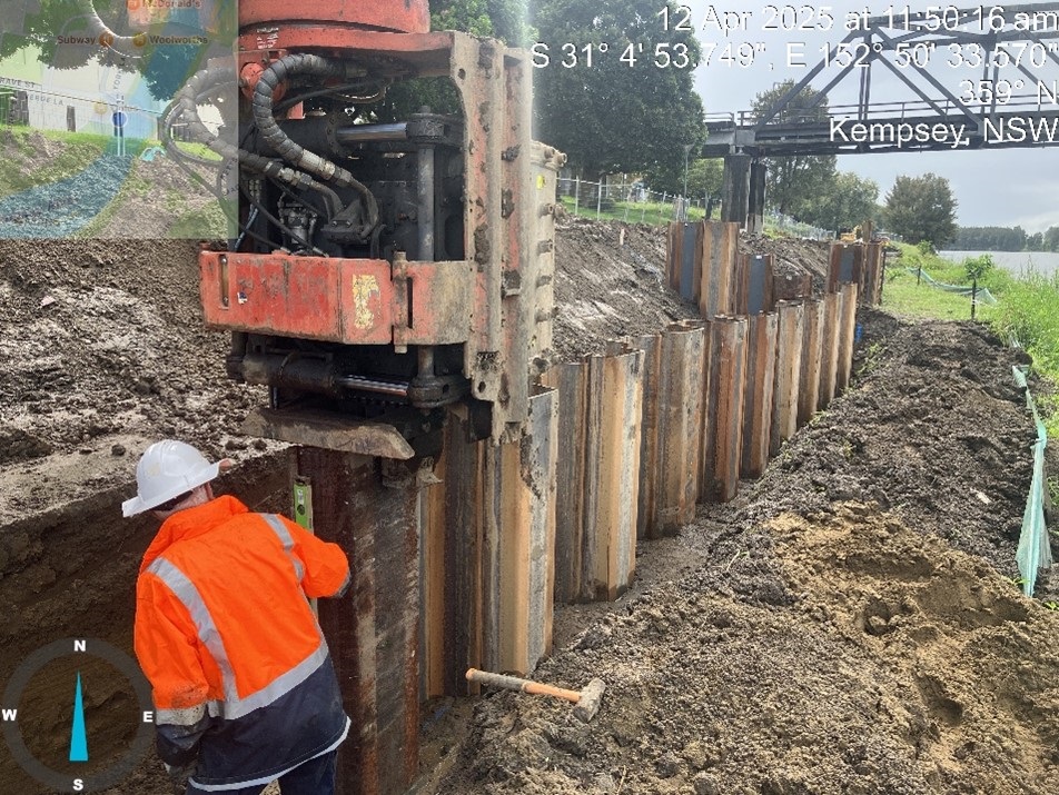
Completion of 336m of sheet piling, 150m of capping beam, 16 CHS units.
September 2025
From Monday 22 September, sheet piling works will commence in the area west of the boat ramps as pictured below. Access to the foreshore will be limited.

December 2025
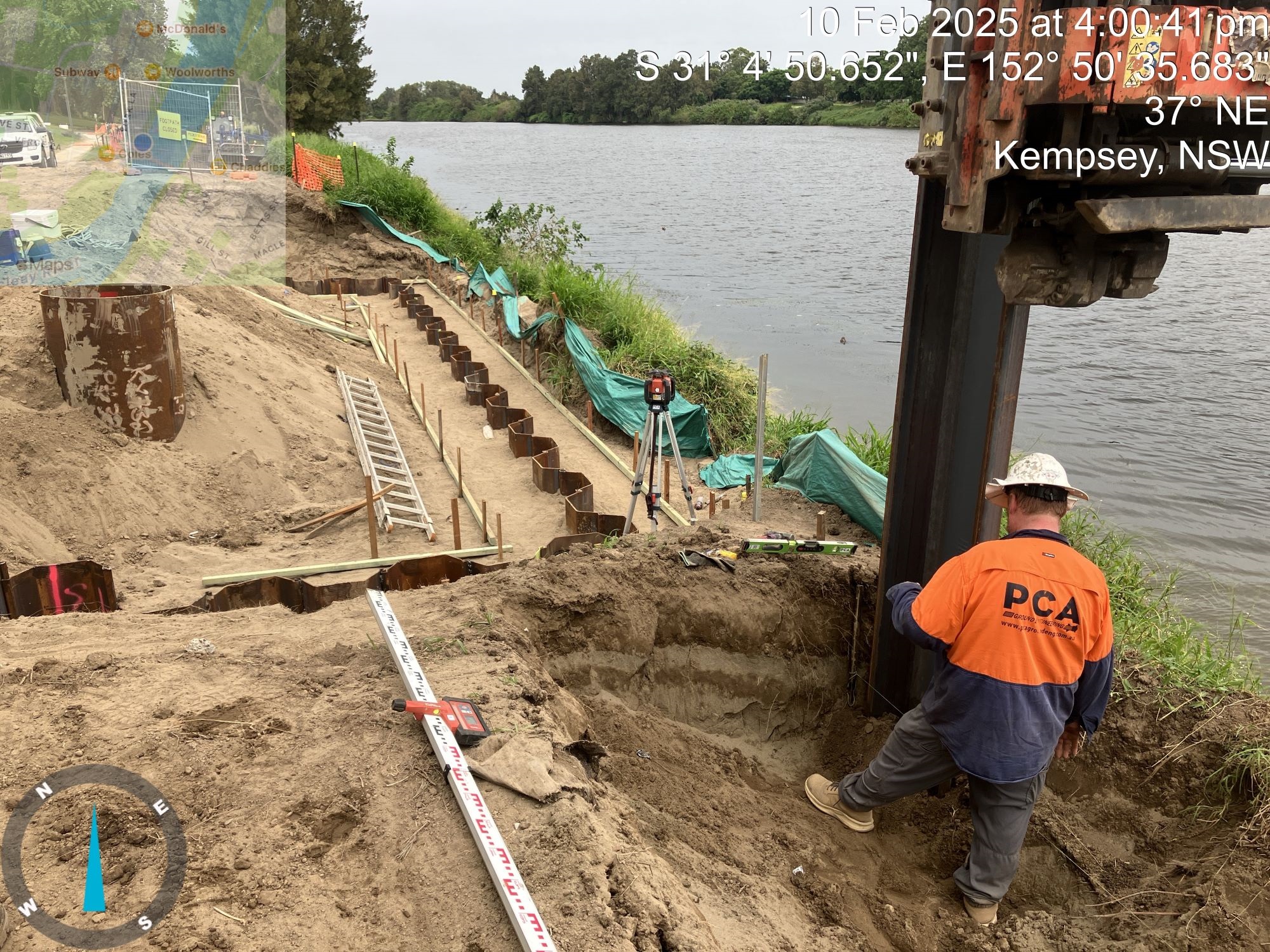
Estimated date for completion of sheet pile wall component. Footpath and wharf works to commence, weather permitting. Below is an example of the completed sheet pile wall.

June 2026
Estimated date for completion of footpath and wharf works.
Contact details
Location
Riverside Park, Kempsey 2440 View Map
-31.0822934,152.8418378
Riverside Park ,
Kempsey 2440
Riverside Park ,
Kempsey 2440
Kempsey Riverside Precinct Foreshore Stabilisation